It’s no secret that major changes are coming to Brampton – from a new university, to a new downtown streetscape, to an LRT system, and more, Canada’s ninth largest city is set to undergo some serio
It’s no secret that major changes are coming to Brampton – from a new university, to a new downtown streetscape, to an LRT system, and more, Canada’s ninth largest city is set to undergo some serious upgrades.
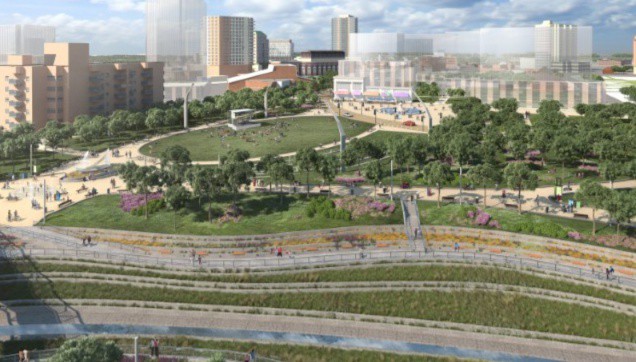
One of those upgrades is the Riverwalk project that’s set to revitalize the Etobicoke Creek in Brampton.
This project has been in the works for some years now. Currently, an environmental assessment is slated for 2018, prior to any construction.
The Riverwalk project sits at an estimated $200 million for a long-term solution to flood risk in Brampton. It’ll run along the Etobicoke River floodplain, aiming to increase potential for urban development and, ultimately, make Brampton more healthy, sustainable and resilient, according to the City of Brampton.
The Etobicoke Creek was once at the heart of downtown Brampton, and the City is planning to reconfigure it where it once fit.
According to the City, this will create a vibrant new space with a distinct identity for Brampton.
“Downtown Brampton lies within the regulatory floodplain of the Etobicoke Creek,” reads the City’s website.
It’s true that in response to frequent flooding a bypass channel lined with concrete with built in 1952.
“While this channel has protected the area from flooding, it does not exempt the downtown from strict provincial regulations that limit development.”
According to the City, it’s actually possible to eliminate the flood hazard by constructing a landform feature – like the one built in the lower Don Valley – and reconfiguring the channel.
Ultimately, the project would also beautify the area around the creek and make for excellent walking and development space.
What could the entire Riverwalk look like once all is said and done?
Let’s take a look!
Aerial view of reconfigured Rosalea Park, looking southwest
View along Etobicoke Creek at John Street looking north towards Queen
Riverwalk at the Queen Street bridge looking north
Reconfigured Etobicoke Creek channel looking south toward the Scott Street bridge
Night view of the reconfigured Etobicoke Creek channel looking south toward the Queen Street bridge